 Online Parks Services';
} else {
echo '';
}
?>
Online Parks Services';
} else {
echo '';
}
?>
Subdivision & Land Development Ordinance
Zoning Ordinance
Zoning Map
Meetings & Agendas
2019 Meeting and Submission Schedule

The Bureau of Planning and Zoning works with the entire community to create a vision for the future of Bethlehem. We attempt to carry out this vision to create a vibrant and sustainable community for the benefit of both current and future generations. Planning is the process of creating long-term visions for places and communities as small as an intersection and as large as a region of the city. The Bureau is a unified, high-performance team that guides land use, zoning and preservation of historic structures, and promotes the comprehensive growth and well-being of the City and its neighborhoods.
The Bureau's 4 member staff administers two important governmental functions:
The use of land in the City of Bethlehem is regulated. Though much of the city is urbanized, vacant land or buildings to be removed, replaced, or substantially altered for a new use are required to be reviewed by the Bethlehem Planning Bureau and the Planning Commission, which administer the Subdivision and Land Development ordinance. Changes to the Zoning Ordinance and comprehensive planning are also administered by the Planning Bureau and Commission. more...
The goal of Bethlehem's new zoning ordinance is to encourage appropriate development in the city's core while maintaining developed neighborhoods and protecting environmentally-sensitive areas. The ordinance has been adopted by City Council. more...
There are three special districts n the City of Bethlehem where a Certificate of Appropriateness is required prior to issuance of a building permit. These districts include areas of the central business districts found on each side of the Lehigh River and the Mount Airy Neighborhood in West Bethlehem. more...
Find meeting schedules and the agendas for upcoming meetings of the Planning Commission, Zoning Hearing Board and historic conservation districts.
more...
Darlene L. Heller, AICP
Director
dheller@bethlehem-pa.gov
Tracy E. Samuelson
Asst. Director
tsamuelson@bethlehem-pa.gov
Craig Peiffer, AICP
Zoning Officer
cpeiffer@bethlehem-pa.gov
Phone: 610-865-7088
Phone (Zoning): 610-997-7640
Fax: 610-865-7330
Bethlehem recently completed a Trail Study, “Beth Connect: A Trail Study”, to outline a program to build on the existing trail network in and around Bethlehem by closing trail gaps, and by connecting Bethlehem’s trails to destinations outside of the City and to larger trail networks. The study suggests ways to promote recreation and cultural amenities through the trail network and to enhance the vibrancy of neighborhoods and businesses in and around the trail network. Goals of the Study include:
Southside Streetscape Enhancement Plan for the South Side Community Benefit District (2013)
The Streetscape Enhancement Plan for the Proposed South Bethlehem Community Benefit District is part of an ongoing process to facilitate the economic revitalization of South Bethlehem.
A Streetscape enhancement plan is recognized as a necessary initiative to enhance the livability and activity in the downtown area. This Plan is not an attempt to design an entire streetscape system, but rather to study and highlight some targeted areas and provide examples of how streetscape enhancements can bring vitality to the downtown. The Plan was prepared by Lehigh University in Partnership with other South Bethlehem community organizations and local businesses and the CIty of Bethlehem.
Census Report for City of Bethlehem
The Census Report contains commonly requested data such as population, housing and income characteristics. Data from 2000 and 2010 were compared wherever possible to reveal data trends. The information is broken down by the 18 census tracts, Lehigh and Northampton counties, and four distinct neighborhoods that make up the City of Bethlehem. Comparisons to the Metropolitan Statistical Area (MSA) comprising Allentown, Bethlehem and Easton are included to compare the City of Bethlehem with the region. For complete census information, go to: http://factfinder.census.gov.
South
Bethlehem Eastern Gateway Vision Plan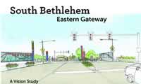
The Eastern Gateway Vision Plan is a community driven report providing ideas for enhancing the major eastern entranceway to South Side Bethlehem, marketing the neighborhood, creating renderings of possible streetscape amenities, and suggesting signage and wayfinding ideas to direct residents, nearby employees, and visitors to all the diverse opportunities offered here.
One of the main goals of the Southside Vision 2012 (now 2014) Plan is to improve the gateways leading into Bethlehem, especially the Eastern Gateway. After a neighborhood visioning party where community residents were challenged to look at their public spaces and make suggestions for improvements and after 13 separate focus groups of community experts convened to discuss ways to enliven and redesign the neighborhood, the plan was finalized in late summer 2011. Implementation of this plan will create exciting and highly visible public spaces as well as much needed retail, service, and residential development in this crossroads neighborhood. The plan was completed in partnership with the Community Action Committee of Bethlehem
In 2009, the City of Bethlehem received a federal Preserve America grant to complete a citywide Historic Preservation Plan (the “Plan”). Bethlehem used this opportunity to create a cohesive strategy to ensure that significant historic and cultural assets in the City—including buildings, neighborhoods, industrial remnants, oral histories, cultural sites and traditions—are preserved and utilized for positive economic and community development. The final plan is attached for reference.
Review the preservation plan. [PDF]
The
City Livable
Modest Proposals for a More Walkable Downtown
In 2009, Jeff Speck, the City’s consultant on walkability and other related planning issues, developed a report based on the conviction that a successful city is one in which people choose to walk. If people are not fully comfortable using the City as a pedestrian, then the City will never provide the high quality of life that is now demanded in our communities. Read more...
Bethlehem's Comprehensive Plan charts how to develop and preserve the City over the next decade. It provides the rationale for updating the City's Zoning Ordinance and for updating other City regulations that affect future growth. Read the full Comprehensive Plan.

The Southside Vision 2012 plan is funded through the Community Action Development Corporation of Bethlehem (CADC-B) and their parent organization, the Community Action Committee of the Lehigh Valley (CACLV) with tax credits from the Pennsylvania Department of Community and Economic Development. The City partnered with CADC-B to complete the plan to develop a strategy for addressing some of the issues and opportunities in the neighborhoods on the south side. The plan was completed in 2002 and a steering committee has been developed to facilitate with the implementation of the recommendations of the plan. The program was previously granted a 2 year extension to 2014. In 2014 the program was reinstituted for another 6 years. The steering committee structure will continue for the next 6 years but will be reorganized to reflect new goals and objectives for the program.
Click here To Download (Adobe PDF File 4091 KB)
South Bethlehem Greenway Master Plan
South Bethlehem Greenway Plan adopted in 2005, the Greenway Plan has been a guideline for Greenway development. The Greenway plan will continue to be referenced as the South Bethlehem Greenway is developed.